


Llangollen - Ellesmere Canal and Cefn Mawr
The Llangollen Canal is the current name of the 44 mile branch leading from the Shropshire Union Canal at Hurleston Junction to Llangollen. Today, although this canal looks like a deliberately cut canal, this is far from the truth and the current canal has resulted from a number of changes in initial planning during the late 1700’s and early 1800’s and continuing on from then until modern times. It was originally the Ellesmere Canal and was planned as a waterway that would link the navigable rivers of the Seven at Shrewsbury, the Dee at Chester, and the Mersey at Netherpool, (Netherpool later becoming Ellesmere Port). This would then provide a seaward export facility for the rich mineral reserves of North East Wales and manufacturing industries of the West Midlands.
In 1791 a proposal for the route was put forward at a meeting in Ellesmere held in the Royal Oak and subsequently the Ellesmere Canal Company was formed. The route as initially suggested was to follow an easterly course crossing the River Dee at Overton, south of Wrexham. This would then have branches cut to Llanymynech, Ruabon and Bersham to give access to the rich Lime, Coal and Iron deposits to be found and in 1792 the Plan of the Eastern Canal & Branches was deposited on the 11th November.
Under the 1792 planning, the Ruabon Branch was to continue on, past Cape Kynaston and Llangollen to the Abby of Crusis and Eglwyseg River where head water for the branch could be drawn. Obviously it is very important to have a head water supply when building canals or they will run dry. Therefore apart from commercial and logistical reasons for building canals at the time, having a reliable head water supply was a fundamental aspect in canal planning & building.
However the Easterly Route did not meet with the approval of all the commercial bakers of the company, and they wanted a more favourable course for their businesses, passing directly through the Welsh mining areas. This resulted in the Westerly Plan being deposited on the 10th of November 1793 after being surveyed by John Duncombe. This then gave two competing routes for the canal and William Jessop, a leading canal engineer was invited to appraise both routes and advise, following which he recommended the Westerly Route. He was subsequently appointed as the Project Engineer, and brought in Thomas Telford as General Agent.
The westerly route posed formidable obstacles, the terrain being more undulating, and would require significant engineering solutions such as aqueducts at Pontcysyllte (Cefn Mawr) and Chirk to cross the Dee and Ceiriog Valleys respectively. In the 1793 plan, tunnels would be required at Chirk, Whitehouse and Ruabon. The Ruabon tunnel being 4067 yards long, or 2.3 miles! This long tunnel was avoided in the 1796 plan where the proposed level of the canal passing through Ruabon was raised 100 feet, but then required a water efficient locking system to bring it down to the level of the Pontcysylte Aqueduct, which was already planned to be 126 feet above the River Dee it was crossing.
The main route of the Western Canal planed from Chester and the River Dee Port was via Hope, Bersham, Ruabon, Plas Kynaston, Pont Cysyllte, Chirk, Hindford, Shade Oak, Weston Lullinfield, Eyton and Shrewsbury thereby joining the River Severn. There would also be four branch lines to the canal for Holt, the Froud Canal and the head water Reservoir at Hope Mountain, Llanymyneck and Whitchurch.
Please note the various spellings for the Ffrwd Canal, Frood & Froud.
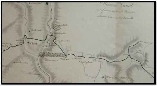
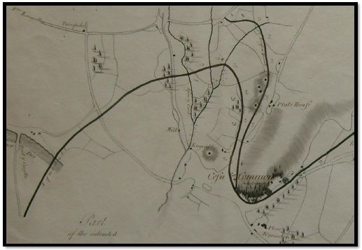
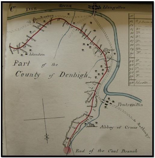 Extract from 1792 Plan for Ruabon Coal Branch continuing to Llangollen for head water
1792 Easterly Route
The planned Ruabon coal branch leading to the Eglwyseg River upstream of the Abbey of Crusis to the north of Llangollen, this extract is taken from the “Plan of the Eastern
Canal and Branches Deposited 11th November 1792”.
The planned route in 1792 called for a branch to be cut on the north side of the Valle of Llangollen. This would have been at a higher elevation than the current line of the canal and thus why the head water supply was sought from the Eglwyseg River and not the River Dee.
Note the head pool or basin and canal marked in red and that north in the 1792 plans is to the bottom of the map / plan, unlike most modern publications today.
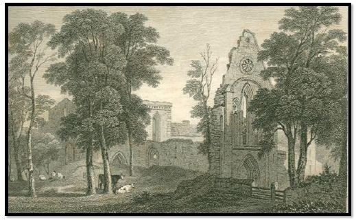 The Abbey of Crusis to the north of Llangollen.
 Extract 1792 Plan for Ruabon Coal Branch continuing to Llangollen for head water
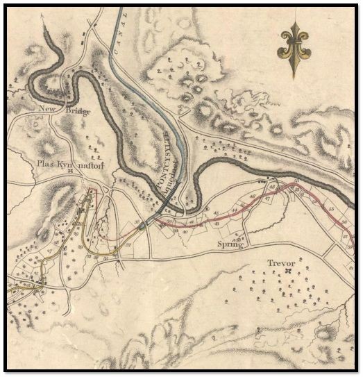
In this extract of the 1792 proposed route, the elevation that the canal would be cut at is indicated by the location of the Plas Kynaston Hall relative to it, i.e. the canal is at a higher elevation than the Plas Kynaston Hall due to being closer to and further uphill as it rounds what was then called the Cape of Kynaston. This would have been at a similar height to Crane Street today as it passes the Holly Bush Inn, central to Cefn Mawr.
 Plas Kynaston Hall, Cefn Mawr
The Plas Kynaston Hall today, a very useful land mark in estimating the elevations of the proposed canal routes as they would have been if continued on to Chester as planned in 1792, 1793, 1795 & 1796.
The Holly Bush Inn, another useful land mark for the 1792 & 1796 proposals can just be seen to the right of this picture where Crane Street Passes to the front of it in Cefn Mawr. Note that the Holly Bush Inn is higher up the hill than the Plas Kynaston Hall so indicating the difference in levels of the various proposals.
 Extract from 1792 plan
Under the 1792 plan the canal would have crossed the River Dee by Overton with what was then a conventional aqueduct of stone and puddle clay bed. This coal branch was planned to give Shrewsbury access to the rich coal deposits at Ruabon, Bersham and what would become Cefn Mawr and the surrounding villages of the Cefn in the Industrial Revolution.
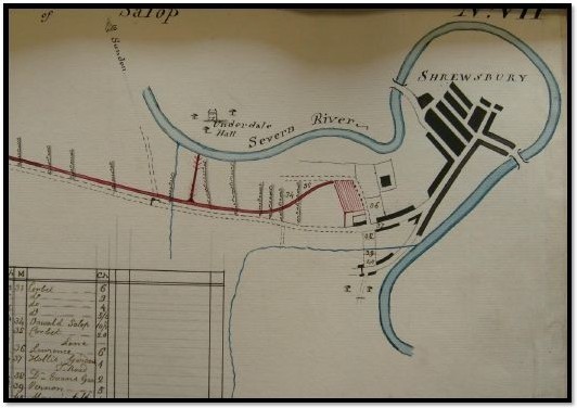 Termination of the Eastern Canal as planned in 1792 at Shrewsbury, note the planned branch linking into the River Severn and wharf at Shrewsbury.
1793 Route
However in 1793 new plans were drawn up that would link in the productive coal mines of Chrik, Ruabon and Bersham along with the rich limestone deposits that could be found at Llanymyneck and Froncysyllte in the Dee Valley. This new proposed route would also join the navigable waters of the River Seven at Shrewsbury, the River Dee at Chester and with a further branch from Chetser, the River Mersey at what would become Ellesmere Port, i.e. the port for Ellesmere in Shropshire and the Ellesmere Canal Company, thus giving seaward passage, both north and south of Wales and linking Liverpool to Bristol via an inland waterway. This was the Western Route crossing the River Dee at a more westerly location, i.e. in the Vale of Llangollen at what became Cefn Mawr rather than by Overton as planned for in 1792. For this to be completed, it required much bolder and technically demanding engineering solutions than simple stone and puddle clay aqueducts. The shear mass of such would prohibit the conventional approach of an aqueduct construction at that time.
Therefore an alternative was sought and the result of which can still be seen today, the Pontcysyllte Aqueduct, a construction of hollow stone piers with a water trough made of cast iron, set upon iron arches resting on the stone piers. This at the time was a revolutionary step forward in technology, as it represented the first large scale use of iron in the civil engineering and construction industry. Furthermore to cross the Ceiriog Valley another aqueduct was required and this being smaller allowed conventional construction of stone pillars and arches with an internal iron trough, i.e. Chirk Aqueduct.
 Extract from 1793 Ellesmere Canal Plan westerly plan
From this extract of the “Plans of Several Extensions & Deviations of and from the line of the Ellesmere Canal and Several Additional Branches, deposited on the 10th of November 1793” it can be seen that had these plans gone ahead, there would NOT have been a Llangollen Canal! Note the canal was not going to Llangollen in this plan as the headwater was planned to be drawn from a reservoir at Hope Mountain in Flintshire via the Froud Canal.
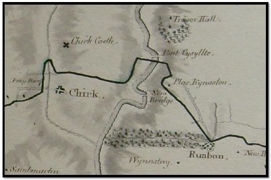 Extract from 1793 Ellesmere Canal Plan, westerly route
Also consider the position of the Plas Kynaston Hall in relation to the planned canal, this would have taken the same route from the aqueduct as was eventually adopted by the Plas Kynaston Canal in the 1820s. It is at a lower level being on the downward side of the Plas Kynaston Hall than the planned route of 1792.
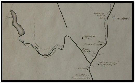 Extract from 1795 Ellesmere Canal Plan, westerly route
This extract of the “Plan of the Intended Canal from Pont y Cysyllte to Chester with the Acrefair, Frood & Holt Branches, Deposited on the 25th September 1795” clearly shows the reservoir at Hope Mountain and the Frood Canal Branch to the main line.
 Extract from 1796 Ellesmere Canal Plan, westerly summit route
1796 Summit Route & The Acrefair Branch, required a higher elevation than that planned in 1793 and hence the adaptation of the 1792 route again through the Cefn Common, one of the main reasons for this amendment was that it would avoid the 2.3 mile tunnel. The summit level increase was from 310 above sea level to 386 feet above sea level.
The line of the aqueduct is clearly marked on the map, but there is no branch planned for Llangollen, and this was the canal they were building at the time, with the first stone for the Pontcysyllte Aqueduct being laid on the bedrock of the River Dee on the 25th July 1795.
This increase in level from the aqueduct to the 1796 summit route obviously required a system for raising the boats. A more efficient means was sought rather than a conventional locking system which uses a lot of water. This was necessary due to the distance from the head water supply at Hope Mountain and the relative dryness and elevation of the area. This lead to some innovative thinking and produced what was probably the world’s first boat lift system. A working model of such was put on display by Experius Pickering at the time in the hope of being successful in winning the contract for the canal.
Then in 1800 plans changed again, after the stone piers for the Pontcysyllte Aqueduct had been built, the canal would no longer be extending any further north than the Vale of Llangollen. However the canal had been cut to this point and two aqueducts almost completed, therefore since the head water supply at Hope Mountain would not be available, alternatives had to be sought. Since the area to the north of the aqueduct was relatively dry apart from a couple of minor brooks, water was sought elsewhere, and Jessop & Telford once again turned their attention towards Llangollen and the possible supply of water from the largest water source in the area, the River Dee itself.
This resulted in Willam Jessop preparing:

 Extract from William Jessop's 1803 Rail Road plan including canal branch to Llangollen
In this extract of the 1803 plan the Ellesmere Canal is indicated in Blue, the proposed Rail Road in Yellow and the proposed Navigable Water Line or Feeder in RED. This therefore represents the true beginning of the Llangollen Canal. Please note that in this map north is to the bottom of the map. Since the Ellesmere Canal was not going to continue on to Chester as planned in 1793, 1795 & 1796 it was then necessary to provide a head water supply from an alternative source and link in as much local industry as possible to make the canal pay. This then was the main thrust of Jessop and Telford’s planning in 1803. Also note the use of the term Rail Road, which is interesting as William Jessop was also a business partner of Benjamin Outram and it may be his influence that resulted in term Rail Road being used in the title of the map, as it is known that he preferred the term rail road to railway. There is also other evidence in the area, both cartographical and physical, to indicate the association of William Jessop and Benjamin Outram in the construction of the early mineral rail roads.
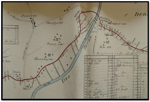
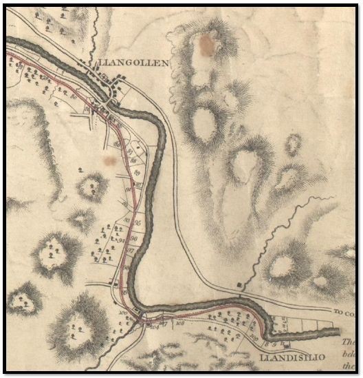 Extract from Jessop's 1803 plan showing the canal branch / feeder to Llangollen
Here the navigable feed line can be seen passing Llangollen as it still does today en route to the Horse Shoe Falls at Llantysilio where the level of the River Dee was raised to feed the canal via a sluice gate.
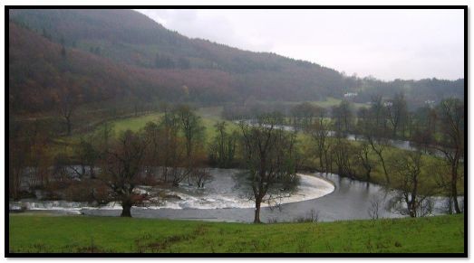 The Horse Shoe Falls in the River Dee at Llantysilio upstream of Llangollen in Denbighshire.

The level of Bala Lake was also raised to ensure the continued flow of the River Dee during dryer times and drought periods to feed the Ellesmere Canal at Llantysilio vai the Horse Shoe Falls and this civil engineering remains very pertinent even today, well over 200 years later.
Sequence of Events:
1791 A meeting is held in Ellsemere regarding what would become the Ellesmere Canal
1792 The Eastern Route Plans are deposited
1793 The Weston Route Plans are deposited
1793 Act of Parliament is passed allowing Ellesmere Canal company to build the canal.
1794 Construction begins
1795 Construction of the Pontcysyllte Aqueduct begins
1796 Revised plans for summit route between Pontcysyllte and Chester are deposited
1796 Llanymynech Branch was opened, linking into the main line at Frankton Junction.
1796 The reservoir at Hope Mountain to provide headwater for the canal between Trevor Basin and Chester via the Ffrwd Canal and a basin in Summerhill is completed.
1797 The Montgomeryshire Canal is opened joining the Ellesmere Canal at Carreghofa Locks & The contour section from the River Mersey to the River Dee at Chester was joined to the Chester Canal.
1800 The main western route of the canal to Chester beyond the Trevor Basin is cancelled as is the continuation to Shrewsbury from Weston Lullingfields.
1801 On the main line section the Chirk Aqueduct was opened.
1802 Chirk Tunnel is completed
1803 The Llangollen Feeder Line is proposed.
1805 Pontcysyllte Aqueduct was opened.
1806 The link between Frankton Junction and the Chester Canal at Hurlstone is completed
1808 Horse Shoe Falls at Llangollen and raising of Bala Lake completed
1813 The Ellesmere Canal Company merges with the Chester Canal Company
1830 The Plas Kynaston Canal is opened as far as the Queens Hotel
1835 The Birmingham and Liverpool Junction Canal is opened joining the Ellesmere and Chester Canals at Natwhich opening up the canal network to Wolverhampton and the midlands inland waterway network.
1840 The Railway arrives in Chester
1846 More companies join together to form the Shropshire Union Canal
1846 Shropshire Union Railways and Canal Company formed
1894 Manchester Ship Canal opens encouraging major growth at Ellesmere Port
1914 The First World War sees high explosive production at Graesser's Chemical Works in Cefn Mawr which are transported from site via the canal system rather than rail due to the explosive nature of the product.
1919 Monsanto Chemicals enter into a partnership with Graesser's Chemical Works and uses water from the Plas Kynaston Canal fed from the Llangollen feeder for cooling etc. with large settlement ponds in lower Cefn
1922 Shropshire Union taken over by London & North Western Railway
1944 many canals were closed by an Act of Parliament but the section now named the Llangollen Canal was kept open to feed Hurleston Reservoir
1945 The Llangollen feeder breached at Sun Trevor causing Monsanto Chemicals Cefn Mawr to run out of water and so the alternative pumping stations on the Dee River were built, and the slow demise of the Plas Kynaston Canal leading into Monsanto Chemicals begins
1947 Tom Rolt, the co-founder of the IWA tries to navigate the Llangollen Canal
1948 Waterways nationalised under British Transport Commission
1950 Water is supplied to Natwich from the River Dee via the branch leading to Llangollen
1955 Agreement with the Mid & South East Cheshire Water Board secured the canal's future.
1957 Last regular commercial traffic on canal through Chester
1962 British Waterways created by the Transport Act
1976 The Boat Museum opened at Ellesmere Port
1980 The former Ellsmere Canal is rebranded the Llangollen Canal by British Waterways
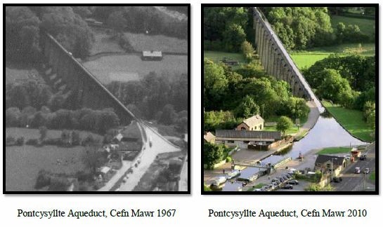
2004 The Pontcysyllte Aqueduct is refurbished
2007 The final 25mt section 30mt of the Plas Kynaston Canal is filled in.
2008 Monsanto Chemical works closes 80% of the plant at Cefn Mawr
2009 Air Products closes its entire plant at Cefn Mawr
2009 The 18km section of the Llangollen Canal between Llantysilio and Chirk was awarded UNESC World Heritage Site status.
2010 The Plas Kynaston Canal Group is started to try and get the half mile Plas Kynaston Canal reinstated following the virtual closure of the Monsanto Chemical Works, once again reconnecting Cefn Mawr with the Llangollen Canal.
Llangollen Canal in the Present Day
Despite the formal closure in 1944, increasing popularity of the canal with pleasure boats led to its acceptance as an important amenity, and the rebranding as the Llangollen Canal in the 1980’s by British Waterways. This rebranding exercise of Britain's industrial waterways as leisure destinations has encouraged usage and promoted restoration. Today in the 21st century the Llangollen Canal is the busiest section of the inland waterway network, with approximately 18,000 boat movements annually.
Since gaining UNESCO World Heritage Site status the Pontcysyllte Aqueduct has become one of the top tourist attractions in North East Wales, drawing over 250,000 visitors annually.
As a result of the early work by pioneering enthusiasts for pleasure boating on Britain’s Inland Waterways, and the continued work of volunteer groups, associations, authorities and commercial enterprises there has been a significant improvement in the condition of our remaining waterways with many reopening’s. This in turn has led to a small but significant sector of commercial trade and industry that has been borne out of the second resurgence of use of our inland waterways and is something to be proud of.
Down load this PDF to print out this web page on any printer, and thanks for taking an interest, regards PKC Group.
Llangollen Canal Cefn Mawr.pdf
Adobe Acrobat document [2.1 MB]